banniere TrackandRoad
| Connect

Aidez le site : faites un don Paypal

From Beaujolais to Charollais

Take part

Don't forget to publish your favourite biking roads.

Use Motorbike-roadbooks

You can create custom roadbooks based on these roads by using software Motorbike-Roadbooks. For a first use, you can have a look at the tutorial.

Map

Zoom back to initial map

Description

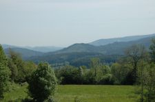
Located in the outskirts of Lyon, this nice road is a charming link beetween Beaujolais and Charollais.

There is about 25 kilometers of slow or fast curbes, but in all cases with a perfect road surfacing and a relaxing atmosphere : you are in the middle of forests and 1000 m hills.
Pictures

Col des écharmeaux

Marks

The roadbook

23.5 km (about 23 min)

Stage Instructions Distance Zoom crossing
Beaujeu 0 km
1 Head east toward D337 PK : 0 km
(-> 0 km)
2 Turn left at D337 PK : 0 km
(-> 13.9 km)
3 At the roundabout, take the 1st exit onto D385 PK : 14 km
(-> 2.9 km)
4 Continue on D985 PK : 17 km
(-> 4.6 km)
5 Turn left at D39/D985
Continue to follow D985
PK : 21.6 km
(-> 1.8 km)
Chaufailles 23.5 km

Nearby roads

  • See roads closer than : kms

Research radius : 100 km

Road Length Distance / Active road Mark
In Between ! (South of Lyon) 22.6 km 63 km 3.9/5
De Vaugneray à Thurins (Monts du Lyonnais) 32.8 km 47 km 3.8/5
St Etienne à Annonay 41 km 83 km 3.8/5
Vers le Lac Genin 11.1 km 86 km 3.7/5
Instead of N7, on Ardeche side (North part) 57.8 km 94 km 3.6/5
D'Ambert à Issoire 58.5 km 86 km 3.6/5
Entre Auvergne et haute Loire 45.3 km 69 km 3.6/5
De Givors à Rive de Gier 11.2 km 64 km 3.6/5
Route des sept chemins 2.7 km 56 km 3.6/5
Col de Malval 12.3 km 46 km 3.6/5
Route du parc du Pilat 13.5 km 71 km 3.6/5
Col de Pavezin (Pilat) 22.8 km 76 km 3.6/5
Route Gaspard des Montagnes 53.5 km 99 km 3.6/5
Morvan Express : Montsauche - Chateau Chinon - Autun 64.4 km 84 km 3.5/5
Col de la République (Pilat) 24.7 km 83 km 3.5/5
Route de Mornant 1.5 km 61 km 3.5/5
Route de Soucieu 4.8 km 53 km 3.5/5
Col de l'oeillon 21.2 km 81 km 3.5/5
Entre loire et haute loire 21.6 km 86 km 3.5/5
Parc du pilat 26.2 km 69 km 3.5/5
Foret de Taillard (Pilat) 28.8 km 95 km 3.5/5
Bugey 44.1 km 64 km 3.5/5
St Laurent - Lac de Vouglans 38.4 km 92 km 3.4/5
Le Pin Bouchain 7.6 km 30 km 3.4/5
Parc du pilat 20.6 km 74 km 3.4/5
Hauteurs de Givors 6.3 km 61 km 3.3/5
Les collines du pilat 17.5 km 75 km 3.3/5
Gorges de la Sioule 93.4 km 98 km 3.2/5
Ain valley and Bethiand pass 24.4 km 57 km 3.1/5
Biche pass - Grand Colombier mountain 33.1 km 85 km 3.1/5
Cerdon pass 17.6 km 64 km 3.1/5
From Oyonnax to St Claude 33.6 km 84 km 3.1/5
Cremieu 18.7 km 69 km 3.1/5
Outskirts of Macon 51.8 km 21 km 3/5
Golden stones villages in Beaujolais 16.8 km 24 km 3/5
Vouglans lake (west coast) 38.5 km 84 km 3/5
The heart of south Burgundy 59.1 km 44 km 2.9/5
Beaujolais express 34.1 km 6 km 2.9/5
Cheminée pass 23.6 km 74 km 2.9/5
Bois clair pass 7.7 km 24 km 2.9/5
Mt St Vincent - Cluny - Montceau 40.8 km 31 km 2.9/5
Two rocks trip in southern Burgundy 12.6 km 18 km 2.8/5
De Nantua à Oyonnax 31.6 km 78 km 2.8/5
Montlucon donzy 183.3 km 32 km 2.7/5
Les étangs de la Dombe 50.7 km 40 km 2.5/5
Le canal (Montceau - Paray) 36.5 km 34 km 2.5/5
D27 Chateau-Chinon / Luzy 36 km 74 km 2.5/5
D978 Autun / Chateau-chinon 34.3 km 85 km 2.5/5
Gorges de l'ain 79.6 km 57 km 2.4/5
De pont d'ain à Poncin 10.6 km 59 km 2.2/5

Nearby Accomodations

  • See accomodations closer than : km

Research radius : 100 km

Name Type Distance / Active road Mark Zoom
Domaine de la vallée Bed and breakfast 38 km 4.7/5
Domaine A l'orée des buis Bed and breakfast 70 km 4.5/5
auberge de la forie Hotel 81 km 4.1/5
Evasion et Loisirs pour tous Bed and breakfast 29 km 3.4/5

Your opinion

There is no opinion about this road yet.