banniere TrackandRoad
| Connect

Aidez le site : faites un don Paypal

Deutsche Alpenstrasse (western part)

Take part

Don't forget to publish your favourite biking roads.

Use Motorbike-roadbooks

You can create custom roadbooks based on these roads by using software Motorbike-Roadbooks. For a first use, you can have a look at the tutorial.

Map

Zoom back to initial map

Description

The western part of the Deutsche Alpenstrasse goes from Garmisch Partentkirchen to Bodensee. No passes, but a charming road cruising in the middle of hills, forests with nice and curvy downhills, especially the one going down to Bodensee.

There is just the same problem than on the east, the road is very touristic, so there might be a lot of traffic.
Pictures

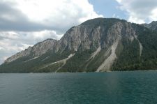
Plansee
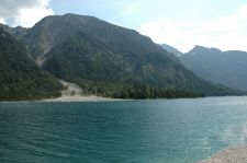
Plansee (2)

Marks

The roadbook

150.2 km (about 2 h 24 min)

Stage Instructions Distance Zoom crossing
Garmisch Partenkirchen 0 km
1 Head southwest on B23 toward Werdenfelser Str. PK : 0 km
(-> 4.3 km)
2 Turn left onto Ettaler Mühle/St2060 (signs for Reutte/Tirol)
Continue to follow St2060
Destination will be on the left
PK : 4.3 km
(-> 9.6 km)
3 Head west on Linderhof/St2060
Continue to follow St2060
Entering Austria
PK : 13.9 km
(-> 6.8 km)
4 Continue onto Ammerwald/L255
Continue to follow L255
Destination will be on the left
PK : 20.7 km
(-> 13.2 km)
5 Head west on Am Plansee/L255
Continue to follow L255
PK : 34 km
(-> 4.5 km)
6 At the roundabout, take the 2nd exit onto Kreckelmoosstr./L255
Continue to follow Kreckelmoosstr.
PK : 38.5 km
(-> 0.8 km)
7 Turn right onto Innsbrucker Str. PK : 39.4 km
(-> 0.9 km)
8 Continue onto Lechtal Str./Obermarkt/B198 PK : 40.4 km
(-> 0.6 km)
9 At the roundabout, take the 2nd exit onto Lechtal Str./Lindenstr./B198
Continue to follow Lechtal Str./B198
PK : 41 km
(-> 8.2 km)
10 At the roundabout, take the 1st exit onto Sommer/Tannheimer Str./B199
Continue to follow B199
Entering Germany
PK : 49.3 km
(-> 22.4 km)
11 Continue onto B308 PK : 71.7 km
(-> 3.2 km)
12 Turn left to stay on B308 PK : 74.9 km
(-> 1.9 km)
13 Turn right to stay on B308
Go through 1 roundabout
Destination will be on the left
PK : 76.9 km
(-> 8.7 km)
14 Head west on B308 toward Imberger Str. PK : 85.7 km
(-> 4.4 km)
15 Merge onto B19/B308 via the ramp to Lindau/Immenstadt/Kempten PK : 90.1 km
(-> 4.8 km)
16 Take the exit toward Füssen/Rettenberg PK : 94.9 km
(-> 0.2 km)
17 Turn right onto OA5
Go through 1 roundabout
PK : 95.2 km
(-> 1.6 km)
18 At the roundabout, take the 1st exit onto Sonthofener Str. PK : 96.8 km
(-> 0.8 km)
19 Slight left onto Staufenerstraße PK : 97.6 km
(-> 0.5 km)
20 Continue onto Bahnhofstraße/B308
Continue to follow B308
Go through 3 roundabouts
PK : 98.2 km
(-> 36.7 km)
21 Turn left to stay on B308 (signs for Lindau/Scheidegg) PK : 134.9 km
(-> 1.1 km)
22 At the roundabout, take the 1st exit onto Bächlingen/B308 heading to Lindau
Continue to follow B308
PK : 136 km
(-> 12.1 km)
23 Continue onto B31 PK : 148.2 km
(-> 2 km)
Lindau 150.2 km

Nearby roads

  • See roads closer than : kms

Research radius : 100 km

Road Length Distance / Active road Mark
Col de la Silvretta 28.4 km 70 km 4/5
Col du Timmelsjoch - Rombo (2509 m) 51.3 km 67 km 3.9/5
Au bout du Tyrol 31.7 km 34 km 3.9/5
Gerlospass (1628 m) 61.2 km 68 km 3.8/5
Davos (CH) - Bormio (IT) 99.4 km 86 km 3.7/5
Klausenpass 60.8 km 77 km 3.7/5
Grand prix d'Autriche de Superbike 62.3 km 97 km 3.6/5
Jaufenpass 33.9 km 78 km 3.6/5
Riedbergpass 25.9 km 23 km 3.6/5
Deutsche Alpenstrasse (eastern part) 122.6 km 7 km 2.7/5

Nearby Accomodations

  • See accomodations closer than : km

There is no accomodation closer than 100 kms. Increase research radius (max 250 km).

Your opinion

There is no opinion about this road yet.