banniere TrackandRoad
| Connect

Aidez le site : faites un don Paypal

Coast and Castles

Take part

Don't forget to publish your favourite biking roads.

Use Motorbike-roadbooks

You can create custom roadbooks based on these roads by using software Motorbike-Roadbooks. For a first use, you can have a look at the tutorial.

Map

Zoom back to initial map

Description

Note:look up Lindisfarne Island tide tables when planning

Start at

Alnwick Castle

(Services)

Leave town East for Lesbury then to

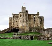
Warkworth Castle.

You can go on to Amble harbour.

Retrace route to Lesbury and turn Right into

Alnmouth,

Lovely beach/river.

Back through village turn right for

Boulmer

Phantom jet at roadside at RAF helicopter s&r base.

Fishing boat Inn food and ale

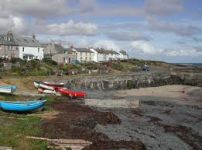
Craster

Famous kippers

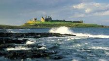
Dunstanburgh Castle

Looking along beach to

Low Newton by the sea

Great drop into village

Fishing boat inn vg ale vg food at fishermans cottages by the beach

Seahouses

(Services)

Mini Blackpool

Olde Ship Inn by harbour v good ale/grub nauticalia.

Good run along coast to

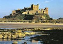
Bamburgh

Magnificent Castle with huge beach behind, air museum in Castle, Grace Darling museum as you leave village

Waren Mill/Budle bay mudflats and birds, views to

Lindisfarne Island.

Stay on this road until the A1 then left on southbound A1 ignore Belford.3mls approx turn right signposted Chatton/Wooler

(services just 400m past this turnoff but on the A1. :::speed camera prior to services)

Chatton

Expansive views of the Cheviots as you drop down to

the village

Percy Arms good food/ale

Retrace route back up hill, turn Left after grey barn on lhs, for

Belford

Good views just along the road from turnoff.

Good chip shop

Carry on for the A1 Northbound to

Beal

(Services)

Lindisfarne Inn good food/ale black sheep.

Turn off for

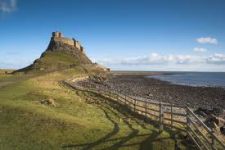
Lindisfarne Island (Holy Island)

CHECK TIDE TIMES People get stuck on the Island or caught by the tide all the time!!

Ignore the no traffic sign, you can park at the harbour or Castle, sensibly! not in the bus layby at the Castle!

Castle well worth a visit but has narrow passageways thet get choked on bank holidays.

Vast Lime kilns just after the Castle and Gertrude Jeykll garden behind Castle in the field.

Ship inn good ale/food

The riding time does not include stops!
Pictures

Alnwick CastleWarkworth Castle
Craster HarbourDunstanbrough Castle
Bambrugh CastleLindisfarne Castle

Marks

The roadbook

103.6 km (about 2 h 04 min)

Stage Instructions Distance Zoom crossing
Alnwick 0 km
1 Head northeast on Clayport St toward Fenkle St PK : 0 km
(-> 0.2 km)
2 Continue onto Bondgate Within/B6346
Continue to follow B6346
PK : 0.2 km
(-> 0.8 km)
3 At the roundabout, take the 2nd exit onto Alnmouth Rd/A1068
Continue to follow A1068
Go through 2 roundabouts
PK : 1.1 km
(-> 10.3 km)
4 Turn left at The Butts PK : 11.4 km
(-> 0 km)
5 Turn right at Bridge View
Destination will be on the left
PK : 11.5 km
(-> 0 km)
6 Head northeast on Bridge View toward The Butts PK : 11.5 km
(-> 0 km)
7 Turn left at The Butts PK : 11.6 km
(-> 0 km)
8 Turn right at A1068 PK : 11.7 km
(-> 5.1 km)
9 At the roundabout, take the 3rd exit onto B1338 PK : 16.8 km
(-> 1.1 km)
10 At the roundabout, take the 2nd exit onto Northumberland St
Destination will be on the right
PK : 18 km
(-> 0 km)
11 Head north on Northumberland St PK : 18.1 km
(-> 0 km)
12 At the roundabout, take the 2nd exit PK : 18.2 km
(-> 1.6 km)
13 Sharp right toward Beach View PK : 19.8 km
(-> 2.9 km)
14 Continue straight onto Beach View PK : 22.8 km
(-> 0.6 km)
15 Turn left PK : 23.4 km
(-> 0 km)
16 Head west PK : 23.5 km
(-> 2.2 km)
17 Continue straight onto Boulmer Rd PK : 25.7 km
(-> 0.2 km)
18 Turn right at N End/B1339
Continue to follow B1339
PK : 25.9 km
(-> 4 km)
19 Turn right at Windyside Hill PK : 30 km
(-> 2.9 km)
20 Turn right toward W End PK : 32.9 km
(-> 0.4 km)
21 Continue straight onto W End PK : 33.4 km
(-> 0.1 km)
22 Slight right at Haven Hill PK : 33.5 km
(-> 0.1 km)
23 Head northwest on Haven Hill toward Dunstanburgh Rd PK : 33.6 km
(-> 0.1 km)
24 Slight left at W End PK : 33.7 km
(-> 0.5 km)
25 Turn left PK : 34.3 km
(-> 0.4 km)
26 Take the 2nd right PK : 34.8 km
(-> 0.2 km)
27 Turn left toward W T Stead Rd PK : 35.1 km
(-> 3.4 km)
28 Slight left at W T Stead Rd PK : 38.5 km
(-> 0.1 km)
29 Turn right at B1339 PK : 38.6 km
(-> 2.1 km)
30 Turn right
Destination will be on the right
PK : 40.7 km
(-> 2.2 km)
31 Head northwest toward Boatmans Pl PK : 42.9 km
(-> 2.2 km)
32 Turn right at B1340 PK : 45.2 km
(-> 2.3 km)
33 Turn right to stay on B1340 PK : 47.5 km
(-> 2.2 km)
34 Turn right to stay on B1340 PK : 49.8 km
(-> 0 km)
35 Take the 1st left PK : 49.8 km
(-> 3.5 km)
36 Turn right PK : 53.3 km
(-> 0.4 km)
37 Take the 1st left toward Ingram Ln PK : 53.8 km
(-> 1.8 km)
38 Continue straight onto Ingram Ln PK : 55.6 km
(-> 2 km)
39 Turn right at Front St/B1341 PK : 57.7 km
(-> 0 km)
40 Head northeast on Front St/B1341 toward B1342 PK : 57.7 km
(-> 0 km)
41 Take the 1st left onto B1342 PK : 57.7 km
(-> 0.1 km)
42 Turn left at Radcliffe Rd/B1342
Continue to follow B1342
Destination will be on the left
PK : 57.8 km
(-> 3.7 km)
43 Head west on B1342 PK : 61.5 km
(-> 0 km)
44 Take the 1st left to stay on B1342 PK : 61.6 km
(-> 0.8 km)
45 Turn right to stay on B1342 PK : 62.4 km
(-> 0.8 km)
46 Turn left toward A1 PK : 63.3 km
(-> 1.8 km)
47 Turn left at A1 PK : 65.1 km
(-> 1.6 km)
48 Take the 2nd right onto B6348 (signs for Wooler/Chatton)
Destination will be on the left
PK : 66.7 km
(-> 8.4 km)
49 Head east on B6348 toward New Rd PK : 75.2 km
(-> 3.1 km)
50 Turn left toward B6349 PK : 78.3 km
(-> 4.8 km)
51 Turn right at B6349 PK : 83.2 km
(-> 1.2 km)
52 Head north on Church St toward The Neuk PK : 84.5 km
(-> 0.1 km)
53 Continue onto N Bank PK : 84.6 km
(-> 3 km)
54 Turn left at A1 PK : 87.7 km
(-> 6.8 km)
55 Turn right toward Lindisfarne Causeway (signs for Holy Island/Beal) PK : 94.5 km
(-> 2.9 km)
56 Continue straight onto Lindisfarne Causeway PK : 97.5 km
(-> 4.8 km)
57 Lindisfarne Causeway turns slightly left and becomes Chare Ends PK : 102.3 km
(-> 0.6 km)
58 Turn left at Green Ln PK : 103 km
(-> 0.1 km)
59 Turn left at Sandham Ln PK : 103.1 km
(-> 0.2 km)
60 Take the 1st right onto Crooked Loaning PK : 103.3 km
(-> 0.2 km)
61 Head east on Crooked Loaning PK : 103.6 km
(-> 0 km)
Lindisfarne Island 103.6 km

Nearby roads

  • See roads closer than : kms

Research radius : 100 km

Road Length Distance / Active road Mark
Border ramble 98.9 km 17 km 3.6/5
Border ramble (west) 110.4 km 28 km 3.6/5

Nearby Accomodations

  • See accomodations closer than : km

There is no accomodation closer than 100 kms. Increase research radius (max 250 km).

Your opinion

There is no opinion about this road yet.